Bryn Mawr to Manayunk via the Cynwyd Heritage Trail and the Manayunk Bridge Trail

Posted in Bike light, Bike to Manayunk on June 21, 2016 by bradhorn77

Bryn Mawr to Manayunk via the Cynwyd Heritage Trail

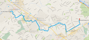
https://goo.gl/maps/BHEJFtD6RPs

It takes about 50 minutes to ride to the top of the Cynwyd Heritage Trail and then another 20 minutes or so downhill into the far reaches of Manayunk. You’ll likely want to stop on the bridge at a couple places to take a pic or two, especially of the sunset or moon rise.

You can’t beat this during a rush hour ride. Hardly any cars or vehicle pollution on route to deal with and the scenery is just beautiful! There are some hills involved, for sure, but nothing too difficult that a steady pace can’t handle. It’s so worth it!

For night time riding make sure you have a really bright bike light. I love my 600 lumen NightRider (600 lumen setting for 1.5 hours, 400 for 3, and 275 for 4.5. Also includes an annoyingly very bright flasher). Particularly handy when I want to ride fast and be able to clearly see the road quality details in far enough advance time to react well within reason. Cars and trucks down the road will often move over because they aren’t sure what vehicle could be so bright and so opt to get out of your way. Kinda inverts the situation for us cyclists!

Bryn Mawr to Manayunk to South Street Whole Foods Market

Posted in Bike to Center City, Bike to Manayunk with tags , , , , on September 28, 2014 by bradhorn77


Bryn Mawr to Manayunk to Whole Foods on South Street

How to get to Manayunk and South Street from the Bryn Mawr area. Click for interactive Google map.

Check this out. Here’s a route from the Bryn Mawr Hospital area to Manayunk and then on to Center City, specifically the Whole Foods Market on South Street. It can take between 35 minutes and 50 minutes to arrive at Manayunk, depending on how fast you ride. It’s about another 30 minutes or more from Manayunk into the center city area.

Havertown to Manayunk

Posted in Bike to Manayunk on July 18, 2009 by bradhorn77

It usually takes about 25 minutes to drive to Manayunk (via City Line Avenue or Narberth to Rock Hill Road). Today it took me just 30 minutes to bike it! Kinda surprised me.

Havertown To Manayunk in half an hourClick on it for a customizable version

The first part of riding to Narberth is fairly easy. And heading down Woodbine Avenue is straight forward and not too busy, at least not when I rode. However, it is a precursor to the steep hills that lie just ahead in particular once you cross Conshohocken State Road (Rt. 23) and hit Jefferson Street.

Jefferson Street and the adjacent streets (Ashland Street, for example) are really very steep! They remind me of Lombard Street in San Francisco! In fact on my return trip, it was so steep at one point on Ebenezer Street, I was afraid the back of my bike was going to flip over the front. That’s what it felt like to me as I braked the entire way down under 10 mph. I was not comfortable riding on that steep a hill! Wow, I don’t experience that very often!

Havertown to Conshohocken

Posted in Bike to Conshohocken on September 11, 2008 by bradhorn77

I used to strap my old 32 lb. Panasonic bike onto a bike rack on the trunk of my car and drive out to Conshohocken where I’d start riding on the river path out to Valley Forge and beyond. But with my lighter weight 20 lb. Jamis Quest I don’t have to burn any more gas! I’ve worked out a great bike route out to Conshohocken that takes about 50 minutes for the 9 mile trek. Its a real aerobic workout in and of itself, believe me!

Click here for an interactive detail view.

Man is it hilly!!! Its fairly easy going on the south side of Lancaster Avenue Rt. 30. From there on in its a bit of a roller coaster ride. And it gets more challenging as you approach Conshohocken.

A major strategy here is to totally avoid Rt. 23 (Conshohocken State Road) as its very narrow, there often is no shoulder on the road, and there are plenty of cars eager to get somewhere. I’d only be in their way. So I intently studied the Google satellite map of the area and discovered something wonderfully slick. According to the maps, Rene Road and Spring Garden Street do not connect (zoom out the map and you’ll see why this matters). But if they did, it would seal the deal, so to speak. My reality check confirms that the two streets don’t explicitly connect. However, someone put this very nice short (less than 10 feet) stone access path between them. Hallelujah!!! That tiny detail makes all the difference!

Havertown To Center City, Philly

Posted in Bike to Center City on August 31, 2008 by bradhorn77

Sometimes I just want to ride into center city Philadelphia (about a 20 mile trek round trip / 1 hour each way). Only all those cars, busses and trucks are in the way! Yuck! Well sometimes the only way to accomplish something is with a little compromise. I believe I’ve worked out one here…

Click here for an interactive detail view.

Its important to pay attention to the traffic, whether there is debris on the street or sidewalk, and whatever else. I’ve driven this route many times and have noticed that sections are actually designated for bicyclists, which helps a lot. A reality check shows that those areas are mostly free of much traffic and the neighborhoods seems low key enough to ride through, some with nice gardens. Not everywhere, some.

Here are some tips…

  • Pretty much everything up to and including Upland Way is relatively uneventful in traffic. Its a breeze. However, as you ride around the 54th and Jefferson Streets, you might encounter some debris to watch out for on the sidewalk. Its a short distance. Your choice here is riding with the traffic or on the sidewalk
  • for the short Parkside Avenue run, take advantage of the paved sidewalk across the street on the other side of the street trees, which will alleviate some traffic concerns
  • taking the North Concourse Drive is a breeze and the road seems plenty wide enough for both cars and bicyclists. Nice stretch too, where you can really crank the speed up for a bit. Just be mindful of any geese and turtles that might be wandering around
  • take advantage of the sidewalk on Lansdowne Drive on the way to the West River Drive bike path (sidewalk)
  • the section of West River Drive into the city seems free of tree roots and is therefore cool for cranking up the speed, once again, as you head into center city.

After reaching the end of the path in center city, I was amazed how easy it all was! In reality, it took me just a little longer on bike than it would to take SEPTA! Its a good feeling to know that riding a bike into center city is a fun and functional option.

Havertown to Whole Foods in Devon to Performance Bike in Paoli

Posted in Bike to Devon & Paoli on August 16, 2008 by bradhorn77

Riding from Havertown to Whole Foods in Devon was a small feat in and of itself. Its only about 10.6 miles.

Click here for an interactive detail view.

The trouble with riding out that way is the main Route 30 (Lancaster Avenue or even Conestoga Road) – too much traffic. The road doesn’t allow enough room for a bicyclist. And then there is all that air pollution. Who needs it!

Its a good thing that the area has all these beautiful homes, trees and some rolling hills. It wasn’t too difficult to configure a bike route to take advantage of all that – almost entirely. Its the kind of riding space thats a pleasure even during rush hour times.

The trick is to take all the roads that the cars aren’t likely to use, no matter what time of day/night. For example, there is a SEPTA bus road that cuts through Havertown and Ardmore that’s almost always free of any vehicles. There’s a relatively new and beautiful smoothly paved bike path with end points at Radnor-Chester Road, just west of 476, the Blue Route, and at Sugartown Road in Devon, which runs for about 2.5 miles. Nice! The above map illustrates the details of what I mean. Check it out!

I wanted to take it further though. So I came up with a way to get to the Performance Bike store in Paoli. Ya know, ya set your goals and ya go for them.

Click here for an interactive detail view.

The extended ride adds about 4.4 miles, making it about a 30 mile round trip journey. Not bad!

Ridley Creek State Park or Bust!!!

Posted in Bike to Ridley Creek on July 26, 2008 by bradhorn77

Ever since I moved out to Havertown and discovered Ridley Creek State Park I’ve been thinking “wouldn’t it be great if I could ride my bike out to the park!” And for the first time, today I have!

Click here for an interactive detail view.

36.5 miles round trip in about 4.5 hours (5 PM to 9:30 PM), all said and done. Of course I had to meander around Media while I was there. It was a Saturday evening and there was live music playing outside at several venues.

I rode one and a half loops around the park and opted to exit at the Painters Road point. Glad I did because it was almost entirely downhill – for about 2 miles or so – which was great as I got to go really fast!!! Loved it!

2nd Attempt at a Better Route to Media

Posted in Bike to Media, PA with tags , , , on July 12, 2008 by bradhorn77

The previous ride was too hilly and a bit congested with traffic closer to Media. Once I got back, I had to work out a better route. Thanks to Google’s terrain map view, I was able to come up with an easier and even more beautiful trek than before.


Flatter terrain, better scenery, Yeah!

Flatter terrain, better scenery, Yeah!

Click here for an interactive detail view.

All said and done, yesterday it took me (including wandering around Media listening to some musicians ramble) 3 hours (7:30 PM to 10:30 PM) and 22 miles round trip. Actually, I must have spent a good hour meandering around Media listening to music, talking with a few folks, etc. Cool spot on a Friday night.

In case you’re thinking I must be nuts for riding in the dark, fear not! My handy NiteRider headlight is almost as bright as a car’s headlight. Love it!!! Of course I also used my blinking led red rear light. I even came prepared with an extra forward blinking led white light, just in case. Also, most of the roads are lit well enough with everything combined. I was actually more concerned about making sure I’d recognize all the landmarks in reverse – in the dark – so I wouldn’t have to make frequent stops to check my maps. Everything worked out just fine. I’d gladly do it all over again!

Another Great Day! Another Ride – to Media, PA!

Posted in Bike to Media, PA on July 1, 2008 by bradhorn77

The weather was too good today to pass up a bike ride! Today I kinda felt like going someplace I haven’t been before – by bike that is. A ride that might prove to be a challenge. Maybe it would be the hills. Maybe just the difficulty of planning out a safe (from traffic) route without drifting all over the map. Riding to Media seemed to fit the bill. Here’s the overview:

Home to Media, PA

Click here for an interactive detail view.
I got lost a few times. The route is rather convoluted and requires paying attention to street signs while sight seeing. Oh well, that’s half the fun of riding a bike anyway! Also, as you can see from the topological map, its somewhat hilly, which is only great in one direction!

Bicycle rule of thumb: What goes down must come back up! And so went my trek today! Sometimes I streamed along at 25 mph. Other times (hill climbing) I went 4 mph. Gotta go with that low gear folks!!!

All said and done, it took (including a stop or two and some wandering around Media just for the heck of it) about 2.5 to 3 hours and 23 miles round trip.

Phoenixville or Bust!!!

Posted in Bike to Phoenixville, PA on May 25, 2008 by bradhorn77

My Bike

Sunday was such great bicycling weather I decided to take my 20lb. Jamis Quest bike for a little stroll!

I had 2 goals in mind this time. One was to ride from my home in Havertown to Phoenixville and back. The other was to break the 50 mile ride mark. I did both – for the first time!

This illustrates my route (click for a larger detail view) which ended up taking approximately 5.5 hours start to finnish (including rest stops, etc).

It wasn’t too long ago that I managed to break my 40 mile mark. For whatever reason, I’ve been itching for more.